How to Record and Relive a Hiking Route
How to record a hiking route properly — background permissions, photos and voice notes pinned to the map, why distance and elevation read wrong, how to export your track as a GPX file, and how to share a finished hike with people who weren't there.
By TrailsPals · Source-based guide. How we prepare our guides · Suggest a correction

A hike leaves two kinds of record. One is the photos, which everybody takes and almost nobody looks at again. The other is the track — the actual line you walked, with times attached — and it's the one you can't reconstruct afterwards. If the recording didn't run, that hike is gone in a way a forgotten photo isn't.
Recording it well takes about thirty seconds of setup and one permission most people get wrong. Getting it back later — in a form worth returning to, or worth sending to someone who wasn't there — takes slightly more thought about what you capture while you're moving.
How do you record a hiking route on your phone?
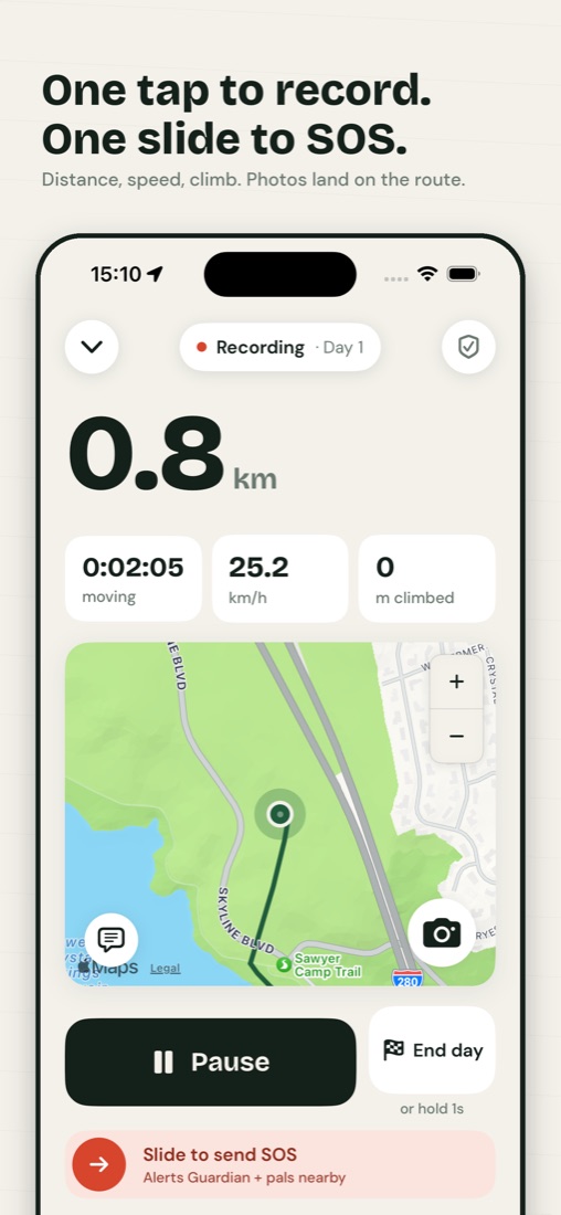
Start the recording before you leave the trailhead, grant the app background location access, and leave the screen off. The app logs a GPS fix every few seconds and joins them into a track. Stop it when you reach the car, not when you get home — an idle recording adds a straight line across the map.
The permission is what actually breaks this. Apple documents the distinction plainly in its Location Services guide: granting an app "While In Use" lets it ask separately for background access, and a tracking app needs that second grant to keep logging once the screen locks. Without it you get a recording that stops the moment you slide the phone into your hip belt, which people usually discover at the summit.
Two other things worth doing in the parking lot, where coverage is usually best:
- Check the recording is running and moving before you commit to it — walk twenty metres and confirm the track extends
- Airplane mode with location services still on if you're heading somewhere with patchy signal; GPS is receive-only and doesn't need a network, and a phone hunting for a tower burns real battery
How do you add photos and voice notes to a recorded hike?
Capture them while the recording is running, so each one carries the coordinates and time it was taken. TrailsPals stores a photo, typed note or voice memo as a point on the same track as the GPS fixes, so it appears where it happened rather than in a separate gallery.
That's the difference between a file with a date on it and a point on the map. Months later you get "the water source, forty minutes past the saddle" rather than a thumbnail you can't place. Voice memos are the underrated one. Talking for fifteen seconds works with gloves on, in rain, while still walking, and it catches things nobody types: that the bridge is out, that the trail junction isn't signed, what the wind was doing. Field-journaling by voice deserves its own post, and will get one.
The practical rule is to capture at decisions, not at views. A photo of a ridge is replaceable. A note recorded at the unmarked fork where you guessed left is not.
Why does a recorded hike show the wrong distance or elevation gain?
Because raw GPS is noisy and the errors only ever add. Position wanders a few metres under tree cover, and every wander counts as distance walked. Altitude is noisier still, so unfiltered gain reads far too high. TrailsPals counts a climb only where consecutive altitude readings rise between one and a hundred metres.
This is why two apps recording the same hike on the same phone disagree, and why neither is lying. What differs is the filtering — and vertical readings are consistently less precise than horizontal ones, so altitude needs more of it. Below that one-metre threshold a change is jitter; above a hundred metres it's a bad fix; neither belongs in your total. Distance, likewise, is computed from the whole recorded path rather than a straight line between endpoints.
Two consequences worth knowing. Older recordings made before a device reported altitude show zero elevation gain — that's missing data, not a flat hike. And if a number matters to you, trust the shape of the track over the third significant figure of the summary. What affects phone GPS accuracy on trails, and what you can do about it, is a bigger subject than one section — it's a post of its own, coming.
What happens to a hike recording when you lose cell signal?
Nothing stops. GPS is a receive-only signal from satellites and works with no cell coverage at all, so the track keeps recording through dead zones and uploads once you're back in range. What does stop is anything being sent — nobody watching from home sees a new position until your phone finds signal again.
That split matters more than it sounds, because it's the difference between two failure modes people conflate. Losing coverage costs you nothing in the record — you'll get the whole hike back. It costs you everything in live sharing, which is exactly why the honest version of how live location sharing works on the trail leads with the dead-zone limit rather than burying it.
If you regularly hike where there is no coverage for hours at a time, that's the point at which a satellite messenger stops being overkill — we compared the options in phone GPS vs a dedicated GPS device.
Does recording a route drain your battery faster?
Yes, but far less than most people assume. Background GPS logging with the screen off is a modest, steady draw. The expensive parts are the display and a phone searching for signal at the edge of coverage — checking the map every ten minutes costs more than recording continuously for the whole hike.
The mitigations are unglamorous and they work: airplane mode with location on, a power bank in the pack, the phone in an inside pocket in cold weather because lithium cells lose usable capacity when they're cold. A full battery strategy for all-day tracking is its own topic and is on the list.
Can you export a recorded hiking route as a GPX file?
Yes. TrailsPals exports a recorded hike as a GPX file. GPX is the open XML format for exchanging waypoints, routes and tracks between programs, and has been the de facto standard since 2002. Exporting a hiking route gives you the track itself, with a timestamp on each point and elevation where your phone recorded it.
What lands in the file:
- GPX 1.1, the current version of the format, readable by essentially anything that reads GPX
- One track, with one segment per recorded day — so a multi-day trip stays separated into days rather than being joined by a straight line across the gap
- Latitude, longitude and a UTC timestamp on every point, which is what makes the track answer "how long did this take" later
- An elevation value wherever the phone reported altitude — older recordings from devices that reported none simply carry no elevation on those points
Two caveats belong in the same breath. Our terms state the first outright: GPX exports are approximate and may omit points, timestamps and metadata. The second is the mechanism behind it — the file is built from the stored track and capped at twenty thousand points per day, which is a very long day before it bites, but it does mean the export is a faithful copy of the recording rather than of every raw fix your phone ever took.
Who can download it follows the trip's own setting. A trip marked private exports only for you; a trip that isn't private can be exported by anyone who can open it, which — as the terms spell out — includes loading it as a planned route and following it themselves. Files travel the other way too: a GPX you already have can be imported and walked as a planned route.
The general advice outlives any one app: check for an export option before you commit several years of hikes to it, ours included. A recording you can't get out of an app is a recording you are renting.
How do you share a recorded hike with people who weren't there?
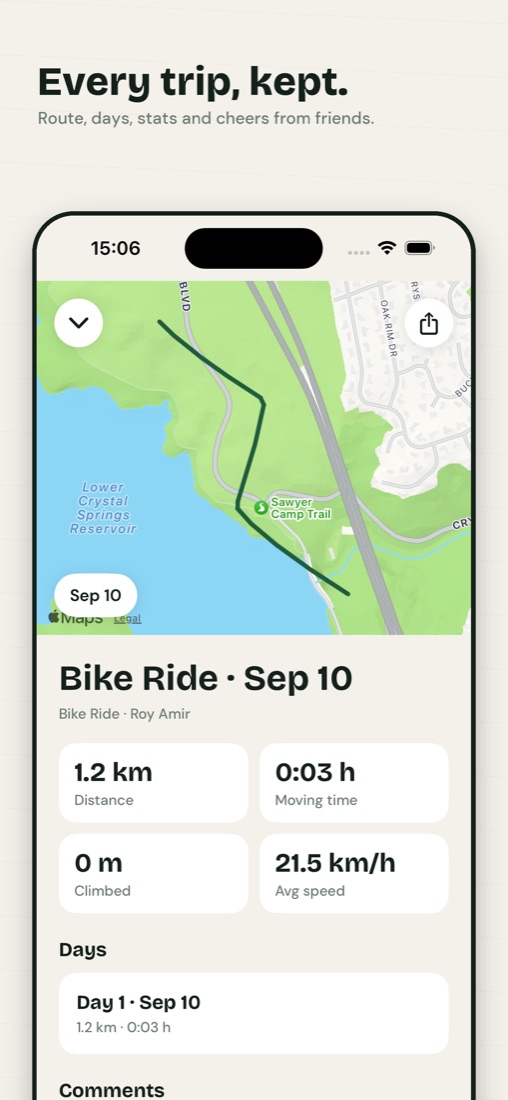
Send the hike, not the photos. A finished TrailsPals journey has a link that opens in a browser — no app install, no account on their end — showing the route on a map, the photos and notes at the points where they happened, and the distance and elevation for the whole trip. There's a guestbook for comments.
One thing to be clear about: that link is public. Anyone who has it can open it, there's no password on it, and a trip you have made public is visible to other TrailsPals users as well as to whoever you sent the link to — route, statistics, photos, notes and all — who may also export it as GPX and follow it. So send it to the people you mean to send it to rather than posting it somewhere indexable. That's the same trade-off that makes it convenient: the person receiving it doesn't have to install anything or make an account to see your hike.
If you want the hike visible but not your name on it, a trip can be shared anonymously, which replaces your name and photo with an anonymous handle for everyone except you. The route and the photos are still public; what changes is whether the trip is attributable to you.
This is also the difference between a recording and a live share. The finished-journey link is a record of a hike that already happened; a watch link during the hike is a safety tool with a countdown to your expected return on it, which is what our hiking safety app page covers. Most people end up using both, for different audiences.
What's worth recording so a hike is worth reliving later?
Less than you think, chosen better. Three or four voice memos at the moments you'd otherwise forget beat sixty photos of the same ridge from slightly different angles. Record the decisions and the conditions — where you turned around, where the water was, what the ground was like — because those are what you'll want next time.
The test is whether the record answers a question your future self will actually ask:
- How long did this take with a pack on? A track with timestamps answers this one for free.
- Was the creek crossing passable? Only answerable if you said something at the time.
- Where exactly did the trail get steep? The track gives you the line; a note tells you how it felt.
The GPS handles the geometry. You have to handle everything the geometry can't record, and that is the whole discipline.
There's a second audience for that, and it isn't sentimental: the notes you leave on a route are the ones that make it repeatable — for you next season, or for whoever you send it to before they walk it. If you're picking a route to record in the first place, our trail guides list day hikes near several cities with the distance and difficulty facts we can back with data.
Before any of it matters, though, the recording has to run and someone has to know where you went. Our day hike safety checklist covers the pre-hike half of that, and solo hiking: a practical safety system covers doing it without a partner — the version of this where the track you're recording is also the last known position anyone has.
See the iPhone app